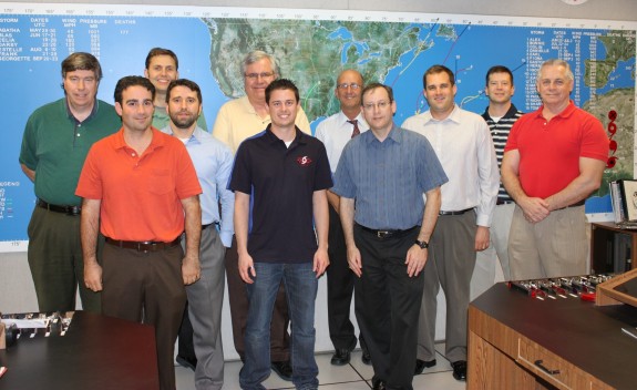
Have you ever wondered who the hurricane specialists (forecasters) are at the National Hurricane Center (NHC) other than just their names you might see on the reports they produce during the hurricane season?
These people are the very best in their field. Not anyone can work as a specialist at the NHC. Only the best of the best were chosen. Although there will be those people who criticize every aspect of what the NHC does, thankfully those people are in the minority. These specialists do more than just view different satellite views and use some of the fantastic software they have (NAWIPS, ATCF, etc.) before they they write up the advisories, forecasts, warnings and other public products – there is a lot more behind the scenes. One thing the general public may not understand is that the specialist when writing up any of these advisory products, there are specific guidelines in how the report is written although there a few qualifiers that do allow some “freehand text” in a few of the reports. The forecaster will check on the latest model runs as this allows the specialist to help forecast where the storm might be heading. The data from the recon aircraft comes from the folks in the CARCAH (Chief Aerial Reconnaissance Coordination, All Hurricanes) office. The forecaster will have many conversations with whoever is staffing that office during the course of a recon mission – as that person is their link to the aircraft crew. The forecaster will also be checking with the TAFB (Tropical Analysis and Forecast Branch) as they provide a storm intensity estimate. The Hurricane Specialist uses the TAFB estimate as guidance but the Specialist will consider all available data in determining the intensity for the advisories.
A normal 6 hour forecast cycle;
The cycle begins, and 45 minutes later there is the reception of the fix data although that is the deadline time. The vast majority are in specialists hands 15 to 30 minutes after synoptic time. Aircraft fixes usually come right at synoptic time or even a bit earlier. An hour after the cycle started – the models are initialized. Again, that is the deadline time, usually the initialization of the models start a bit earlier. A few minutes later, the forecaster receives model guidance and starts the preparation for writing up the forecast. The primary text products in the forecast are the tropical advisory, forecast/advisory, and discussion. The second hour after the cycle started, the hotline call to both the (NWS) National Weather Service and the (DOD) Department of Defense is made. On the third hour, the forecaster has a deadline to release the tropical advisory products. Hours four and five are for possible media interviews. On hour six, the next cycle begins.
When storm watches or warnings are activated or during a landfall event the media is in the NHC building, but usually it’s the Director (Rick Knabb), Deputy Director (Ed Rappaport, PhD), or the Branch Chief (James Franklin) doing those interviews, not the Specialist on duty. There are a few times after the the advisory has been posted someone from the media may call and the forecaster on duty may answer any questions they may might have. When landfall is imminent within a stretch of shoreline, Federal and state level Emergency Managers, the NHC has someone who acts as a liaison between the EM’s and the NHC. Local EM’s are supposed to be in touch with their local WFO (Weather Forecast Office), who in turn relay their concerns to the NHC.
When hurricane season ends (officially) November 30th, the hurricane specialists remain busy outside the hurricane season. Occasionally, storms form before the official beginning of the hurricane season and also after the official end of the season, so specialists still have the responsibility with that storm too. They also have to attend some national and international hurricane conferences. The specialists do help the CPC (Climate Prediction Center), basically to prepare for the annual seasonal hurricane forecast. The specialists must also write seasonal summary articles and also participate in some applied research projects.
UPDATE: When Hurricane Sandy which become Post tropical and why the NHC and the Specialists no longer were issuing hurricane warnings as the very complex and extremely large weather system became a major issue. Basically, the NHC did not have the tools to be able to continue issuing those hurricane warnings. The old system would have caused known and unknown shutdowns within the different products and within the different vendors. Although the NHC would have loved to keep issuing the warnings, the risks were too great. For the 2013 hurricane season and beyond, the NHC now has those tools, recoding the different products and if another storm similar to Hurricane Sandy were to develop, the NHC and the Specialists now have the authority to keep issuing the warnings and other products.
So each hurricane season these specialists (and who get little recognition) are the ones that have to deal with criticism when their forecast might be off, but more times than not, they are very close in their forecast. With budget cuts and the economy the way it is, these specialists can only work with the tools they have available to them. Maybe it’s time for people to really thank the specialists for all the hard work they do.

In this photo from left to right: Jack Beven, John Cangialosi, Eric Blake, Todd Kimberlain, Richard Pasch, Robbie Berg, Lixion Avila, James Franklin, Michael Brennan, Daniel Brown, Stacy Stewart
Not Shown: US Navy Hurricane Specialist LCDR Dave Roberts
Photo credit – Dennis Feltgen