El Niño/Southern Oscillation (ENSO) Diagnostic Discussion
During the latter part of 2010 and the very early months of 2011 the La Niña has been strong to moderate but most of ENSO models are forecasting a weakening of the La Niña within the next few months.
La Niña comes from changes in both the ocean and the atmosphere. High pressure usually dominates the atmosphere over the eastern Pacific, while low pressure tends to reign in the west. The pressure difference creates the trade winds, which blow surface water across the equatorial Pacific to a pool of warm water in the west. Cooler deep water wells up to replace the surface water. During La Niña events, the pressure difference and the resulting trade winds are stronger. The more intense winds push more water west, where it builds up north of Australia. Meanwhile, more cold water wells up in the central and eastern Pacific. La Niña occurs only when both the ocean and the atmosphere change together. The unusual ocean temperatures and imbalance in air pressures alter weather patterns across the world.
Although most models are forecasting the weakening of the La Niña, there are a few that are forecasting a lessening in the the La Niña until the mid-summer months. Whether or not the hurricane season will be a neutral one or an active season is still a little early to forecast.
Synopsis: ENSO-Neutral or La Niña conditions are equally likely during May-June 2011
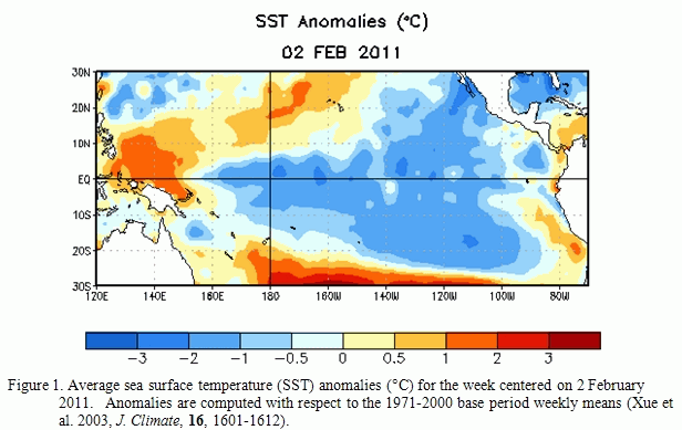
“La Niña persisted during January 2011 as reflected by well below-average sea surface temperatures (SSTs) across much of the equatorial Pacific Ocean (Fig. 1).
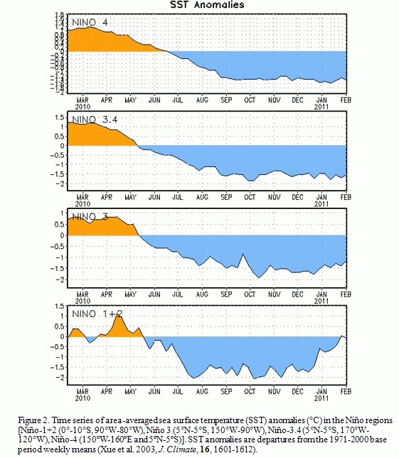
However, some weakening was evident in certain atmospheric and oceanic anomalies, in part due to Madden-Julian Oscillation activity. Most Niño indices were between –1oC and –1.5oC at the end of January, with the easternmost Niño-1+2 region returning to near-average (Fig. 2).
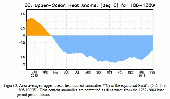
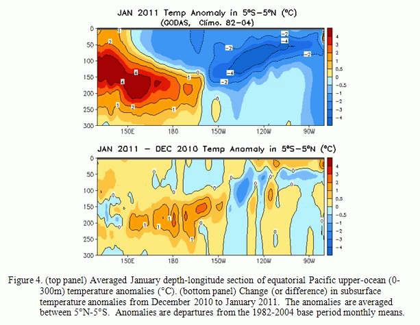
A lessening of the negative subsurface oceanic heat content anomalies (average temperatures in the upper 300m of the ocean, Fig. 3) was observed mostly in association with an eastward shift in the above-average temperatures at depth in the central equatorial Pacific (Fig. 4).
Convection remained enhanced over Indonesia and suppressed over the western and central equatorial Pacific (Fig. 5).
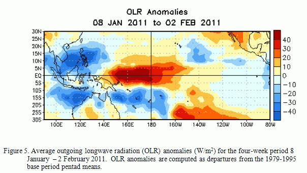
Also over the western and central equatorial Pacific, the anomalous low-level easterly and upper-level westerly winds decreased in magnitude. Collectively, these oceanic and atmospheric anomalies reflect an ongoing, mature La Niña that has begun to weaken.
Nearly all of the ENSO model forecasts weaken La Niña in the coming months (Fig. 6).
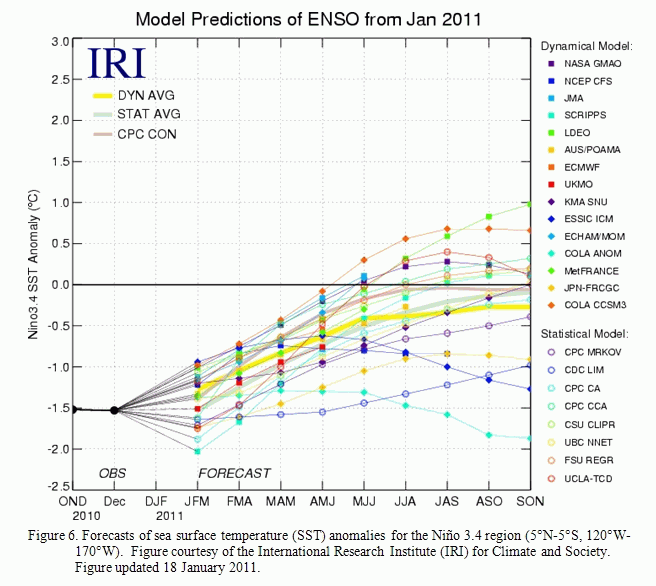
A majority of the models predict a return to ENSO-neutral conditions by May-June-July 2011, although some models persist a weaker La Niña into the Northern Hemisphere summer 2011. Recent trends in the observations and models do not offer many hints on which outcome is more likely. Also, model skill is historically at a minimum during the Northern Hemisphere spring (the “spring barrierâ€). Therefore La Niña is expected to weaken during the next several months, with ENSO-neutral or La Niña conditions equally likely during May-June 2011.
Expected La Niña impacts during February-April 2011 include suppressed convection over the west-central tropical Pacific Ocean, and enhanced convection over Indonesia. Potential impacts in the United States include an enhanced chance of above-average precipitation in the Northern Rockies and western regions of the Northern Plains (along with a concomitant increase in snowfall), Great Lakes, and Ohio Valley. Below-average precipitation is favored across much of the southern states. An increased chance of below-average temperatures is predicted for much of the West Coast and northern tier of states (excluding New England), and a higher possibility of above-average temperatures is forecast for much of the southern and central U.S.” (see 3-month seasonal outlook released on January 20th, 2011).
Click here if you would prefer to see the entire report.