Categories
Tropical Weather

Invest 96L

Although Invest 96L has been around for a few days it is now over the Yucatan Peninsula.

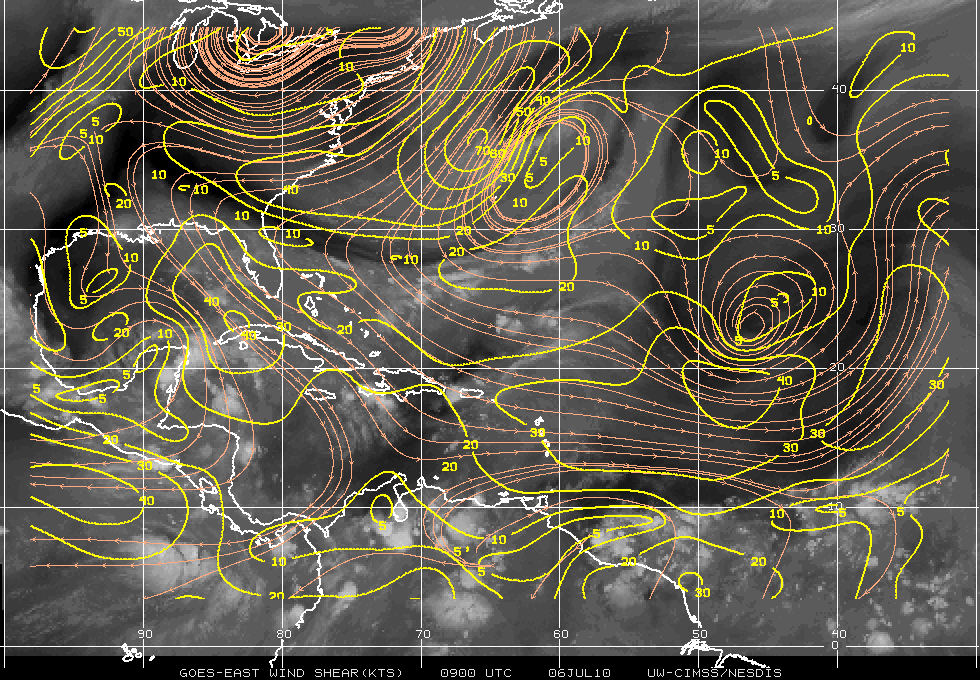
The upper level winds now are in the 20-30 knots range and are not conducive for anything to develop, but the wind shear is forecast to relax in about 36 hours or so.

Wind Shear

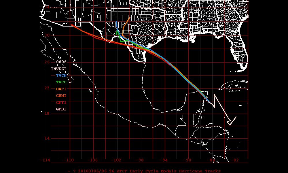
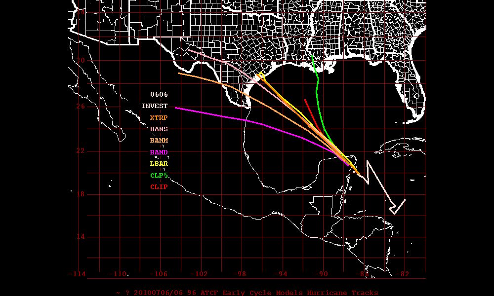
The Dynamic Models do seem to have a better grip than the Statistic Models but remember the models will always fluctuate. At the moment I would tend to stick with the Dynamic Models consensus.

Dynamic Models
Statistic Models

The Steering Layer forecast from PSU Meteorology (not shown) appears that Texas could be threatened but since we don’t even have a center of circulation or developed system yet – time will tell what type of an impact Texas will have, if any.

Categories
Tropical Weather

Was Invest 95L anything tropical?

Did Invest 95L ever meet the criteria to make it a depression or tropical storm? I say NO – it never met the criteria and was nothing but a rain maker with some significant winds.

Tropical Cyclone:
A warm-core non-frontal synoptic-scale cyclone, originating over tropical or subtropical waters, with organized deep convection and a closed surface wind circulation about a well-defined center.

It the time of 1800 (zulu) – 95L had been a frontal boundary. At around 2100 -it detached from the front so it is now on it’s own. Under NHC criteria it requires the organized deep convection to persist for 12-24 hours. Only then if it still meets the criteria – the NHC may classifying a system as a Tropical Cyclone.

Just looking at the radar imagery at the time – it did not have a fully closed circulation. Also the convection was all SW of the “center”. Some people will argue these points and that’s fine – we all have are own feelings. But just using the NHC criteria guide lines  – 95L was just nothing but a  wet and windy storm.

Categories
Tropical Weather

Invest 95L

I don’t see any chance for 95L to organize itself into something tropical. There are upper level winds that in the range of 40-50 knots which pretty much will keep it from organizing.

Some models are just hinting that there might be something else brewing in the GOM in a few days. Lets just hope it is nothing to worry about !!

One a different note – there are allegations that BP is dumping sand over areas where there is oil on the beach.

Categories
Tropical Weather

Hurricane Alex

The first hurricane  of the season, Alex, ripped through Northern Mexico and Central America with wind of 105 mph and is blamed for at least thirteen deaths.  None of the deaths occurred in the regions were there was landfall. Hurricane Alex is now a tropical storm and will probably dissipate over the high mountains in Mexico overnight. Alex was the strongest hurricane  in since 1966. Hurricane Alma had winds of 125 mph as it hit the western coast of Florida.

Categories
Tropical Weather

Invest 93L

Starting yesterday, a system was beginning to catch the eyes of those who are interested in the tropical weather. A modest to strong region of very intense thunderstorms that are in the Caribbean are beginning to look like that we may soon have the first tropical depression (at least in the Atlantic basin). Wind shear in the area is very low, the SST’s are very warm – 29 to 30 degrees Celsius. The MJO (Madden-Julian Oscillation) also does seem to favor tropical development. It is now in the wet-phase over that region. One negative side is there has not been a lot of spin according to the University of Wisconsin 850 mb relative vorticity analysis. 93L will probably begin to get an increased inflow from low level air and help the development of the spin soon.

At this time the NHC is calling for a 40% chance of developing of into a tropical depression. I wouldn’t see that until at least Wednesday maybe even Thursday. The GFS, NOGAPS, and UKMET models have been very reluctant to develop 93L for the time being. The GFDL model is expecting 93L to be a weak tropical storm in the next 5 days. At this time – the GFDL has been flip-flopping so lets just see what happens.

One worry is the possible flooding in Haiti. Any mudslides then there will be some unfortunate deaths. Lets just pray this will not be the case. Haiti has had enough over the past couple years.

As always – please use the NHC or your local weather for official information.

Categories
Tropical Weather

Weather or Knot

Using a play on words the name of this blog just worked out perfectly. Since both the blog and the forum are based mostly for the world of weather (meteorology). The name of the main weather site  http://corioliseffect.net but the blog is http://corioliseffect.net/blog.

I am sure one of the first question to be asked is what is the coriolis effect. That is a great question! In physics, the Coriolis effect is an apparent deflection of moving objects when they are viewed from a rotating reference frame. Unless you are a meteorologist or a scientist – it probably is nothing but word a bunch of words but no meaning.

In Meteorology, perhaps the most important instance of the Coriolis effect is in the large-scale dynamics of the oceans and the atmosphere. In meteorology and ocean science, it is convenient to use a rotating frame of reference where the Earth is stationary. The fictitious centrifugal and Coriolis forces must then be introduced. High pressure systems rotate in a direction such that the Coriolis force will be directed radially inwards, and nearly balanced by the outwardly radial pressure gradient. This direction is clockwise in the northern hemisphere and counterclockwise in the southern hemisphere. Low pressure systems rotate in the opposite direction, so that the Coriolis force is directed radially outward and nearly balances an inwardly radial pressure gradient. In each case a slight imbalance between the Coriolis force and the pressure gradient accounts for the radially inward acceleration of the system’s circular motion.

Hopefully using an animation might give you a clearer idea of what the coriolis efffect is:

Now there still is the myth about the direction of rotation in a bathtub or toilet and that the Coriolis Effect was the cause. While theoretically the Coriolis Effect might affect the draining flow, it is stronger other factors (temperature distribution, turbulence and wall shape) that dominate.